Taranaki Maunga and Egmont National Park: a visitor's guide
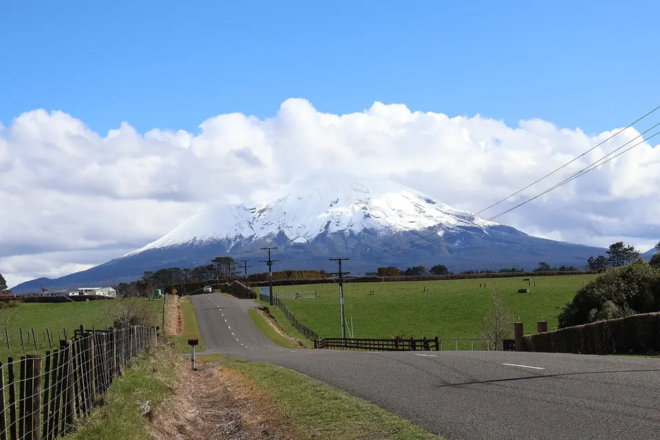
Taranaki Maunga is the reason most people come to the region. The 2,518-metre cone is visible from almost everywhere on the ring plain, and the forest that cloaks its lower slopes is one of New Zealand's oldest national parks. This guide covers how to reach the park, which walks suit which visitors, and why the summit deserves more respect than its regular shape suggests.
A young volcano with a long story
Geologically, the mountain is a stratovolcano, built up from layer upon layer of lava and ash over roughly the last 130,000 years. It is the youngest of a line of volcanoes that runs north-west to south-east: the Sugar Loaf Islands off New Plymouth are the oldest remnants, followed by the worn-down Kaitake and Pouakai ranges and finally Taranaki itself. Fanthams Peak, or Panitahi, is a parasitic cone on the southern flank. Scientists at GNS Science treat Taranaki as an active volcano; its most recent eruptions are dated to the eighteenth century, with possible minor activity in the nineteenth.
For Taranaki iwi, the mountain is an ancestor. Tradition tells that Taranaki once stood among the volcanoes of the central North Island and left after a contest with Tongariro, carving the course of the Whanganui River as he travelled west to his present home. That relationship now has legal form. The Taranaki Maunga Collective Redress Act, passed by Parliament in January 2025, recognises the mountain and its surrounding peaks as a legal person, Te Kāhui Tupua, and renamed the national park Te Papa-Kura-o-Taranaki. Signs and maps are gradually changing, so you will see both the new and the older names, including Mount Egmont, the name given by James Cook in 1770.
The national park
Forest on the mountain was first protected in 1881, when a reserve was declared within a fixed radius of the summit: that is why the boundary forms an almost perfect circle about 9.6 kilometres out from the peak. The reserve became Egmont National Park in 1900, making it the second national park in the country after Tongariro. Inside the circle the vegetation changes quickly with height, from tall rimu and kāmahi forest through the twisted, moss-draped "goblin forest" to subalpine scrub, tussock and finally bare scoria and rock.
The park is managed by the Department of Conservation (DOC) in partnership with the iwi of Taranaki. Dogs are not allowed, drones need permission, and the usual backcountry code applies: take your rubbish out, stay on marked tracks and do not feed the birds.
Three ways in
Three sealed roads climb into the park from the ring plain, each ending at a different starting point.
- North Egmont
- Reached from Egmont Road near Inglewood, this is the busiest entrance and the closest to New Plymouth. A visitor centre and café sit at about 936 metres, with short walks, the Holly Hut track and the main summit route leaving from here.
- Stratford Plateau
- The road from Stratford ends at the highest car park on the mountain, more than 1,100 metres up, beside a small club ski field. It gives quick access to the alpine zone and to tracks around the eastern side.
- Dawson Falls
- On the south-eastern side, reached via Kaponga, Dawson Falls has a visitor centre, a lodge and a cluster of short walks, including the track to the 18-metre waterfall Te Rere o Noke and the route to Fanthams Peak.
All three roads are narrow and winding near the top and can be closed by snow or slips. They are not linked to one another inside the park, so moving between them means driving back down and around on the ring-plain roads.
Short walks
You do not need to be a tramper to enjoy the park. At Dawson Falls, the loop to the falls takes well under an hour, and the nearby Wilkies Pools track follows a stream through a series of smooth rock pools. At North Egmont, short nature walks start beside the visitor centre and give good views of the summit when it is clear. The Kamahi Loop and the walks around the Stratford Plateau are other easy choices. DOC publishes current times and conditions for each track; trust those rather than older guidebooks, as slips and storm damage do close sections from time to time.
The Pouakai Crossing
The Pouakai Crossing is a full-day walk of about 19 kilometres that links North Egmont with the Mangorei Road end on the north side of the park. It climbs past the dramatic Ahukawakawa Swamp, an alpine wetland, and up onto the Pouakai Range, where the small Pouakai Tarn famously reflects the mountain on still mornings. Expect seven to nine hours, plenty of steps and boardwalk, and real exposure to wind and cold on the open tops. Because the walk ends at a different road, you will need to arrange transport between the two ends.
A longer option, the Pouakai Circuit, turns the crossing into a two- or three-day loop with nights in DOC huts. Further afield, the Around the Mountain Circuit is a demanding multi-day tramp for experienced, well-equipped parties.
Climbing to the summit
The summit route from North Egmont is not a formed track for most of its length. It climbs past Tahurangi Lodge, up a long stairway and scoria slope known as the Puffer and the Lizard, and over rock and, often, ice to the crater. In settled summer weather (usually from late December to March), fit and well-prepared walkers can complete it in eight to ten hours return. Outside that window, the upper mountain is an alpine environment that calls for ice axe, crampons and the skills to use them.
Why the warnings matter. Taranaki has one of the worst safety records of any New Zealand mountain. The weather can change in minutes, cloud removes all landmarks, and the smooth upper slopes funnel people who lose the route onto dangerous ground. Check the mountain forecast from MetService and track conditions from DOC on the day, leave your intentions with someone you trust, carry warm and waterproof layers in any season and be ready to turn back.
Out of respect for the mountain as an ancestor, iwi ask climbers not to stand on the very highest point, not to camp or eat on the summit and to take nothing away. Most guided climbs and most visitors now follow that request.
Practical notes
- Huts. DOC huts in the park range from small basic shelters to larger huts such as Holly Hut and Pouakai Hut. Hut tickets or a backcountry pass are needed; see our where-to-stay guide.
- Water. Treat or boil stream water, and carry enough for the open tops, where there is little.
- Clothing. Sturdy footwear, a warm layer, a waterproof jacket and a hat are sensible even on short walks above the bush line.
- Getting there without a car. Some private operators run shuttles to the road ends in summer; services change, so check locally.
Sources
- Department of Conservation, Egmont National Park / Te Papa-Kura-o-Taranaki pages, including the Pouakai Crossing, summit and Dawson Falls track information: doc.govt.nz.
- Taranaki Maunga Collective Redress Act 2025, New Zealand Legislation: legislation.govt.nz.
- GNS Science, "Taranaki volcano" and volcanic hazard information: gns.cri.nz.
- Te Ara, the Encyclopedia of New Zealand, "Taranaki places" and "National parks": teara.govt.nz.
- MetService, mountain and park forecasts: metservice.com.