Surf Highway 45: driving Taranaki's coast road
State Highway 45 follows the western edge of the ring plain for about 105 kilometres, from New Plymouth to Hāwera. Signposted as Surf Highway 45, it is the road that gives Taranaki its reputation among surfers, but it is just as rewarding for anyone who likes empty beaches, small coastal towns and a mountain that keeps reappearing in the rear-view mirror.
Planning the drive
Without stops, the drive takes well under two hours. With stops it easily fills a day, and many visitors split it, spending a night in Ōakura or Ōpunake. The road itself is straightforward: mostly flat, two-lane and sealed, crossing a long series of streams that run straight off the mountain. Beaches are reached by short side roads ending at the coast; many of these cross private farmland, so stay on the road, leave gates as you find them and park considerately.
If you are completing a loop of the mountain, the return from Hāwera to New Plymouth on State Highway 3 passes through Eltham, Stratford and Inglewood. Driving clockwise or anticlockwise makes little difference, but heading south on SH45 in the afternoon puts the evening light over the sea on your right.
New Plymouth to Ōakura
The highway starts in New Plymouth near the port. Just offshore, the Sugar Loaf Islands, Ngā Motu, are the eroded cores of the oldest volcanoes in the Taranaki chain and since 1991 have been protected as a marine protected area, home to seals and seabirds. On land, the steep rock dome of Paritutu rises beside the port; a short, very steep climb leads to its summit for wide views of the coast.
About fifteen minutes south, Ōakura is the first of the beach villages: a sheltered, family-friendly beach, a small cluster of cafés and the backdrop of the Kaitake Range. The breaks around Ōakura and the nearby Ahu Ahu Road are among the most consistent on the coast.
Ōkato, Stent Road and the cape
Beyond Ōakura the road leaves the city's influence behind. Ōkato is a small farming town; nearby side roads lead to some of the best-known reef and point breaks in the country. Stent Road, near Warea, has a reputation that reaches well beyond New Zealand. These are rocky, exposed breaks better suited to experienced surfers: there are no lifeguards, the reef is sharp and rips can be strong.
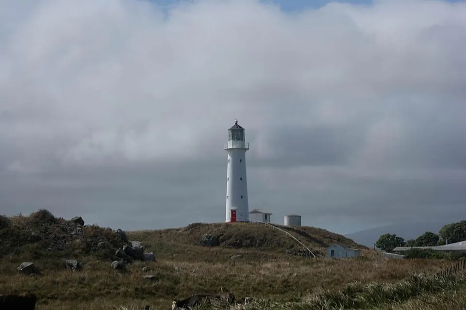
The coast reaches its westernmost point at Cape Egmont. The cast-iron lighthouse here was first erected on Mana Island near Wellington in 1865, then dismantled, shipped and re-erected at the cape, where it was first lit in 1881. It is automated and not open to the public, but it can be seen from the road end, with the mountain often framed behind it.
Parihaka
Inland from Pungarehu stands Parihaka, the settlement founded in the 1860s by the prophets Te Whiti o Rongomai and Tohu Kākahi. In response to the confiscation of Taranaki land, its people led a long campaign of non-violent resistance, ploughing confiscated farms and pulling up survey pegs. On 5 November 1881 some 1,600 armed constabulary and volunteers invaded the village; its leaders were arrested and imprisoned without trial and many residents were expelled. The Crown formally apologised to the people of Parihaka in 2017.
Parihaka remains a living community, not a museum or a tourist attraction. Visitors should not enter without an invitation; the Parihaka International Peace Festival and other public events have, in some years, been the occasions when visitors are welcomed. Reading about Parihaka before you drive this stretch of road changes how the landscape looks.
Ōpunake
Ōpunake is the main town of the southern coast and a natural place to break the journey. Its curved, sheltered beach has a surf club and is one of the few patrolled beaches along this road in summer. A coastal walkway runs along the clifftops and around the lake behind the town, and the town's walls carry a series of large outdoor murals. Ōpunake also has a holiday park on the beachfront and a handful of cafés.
Manaia and Hāwera
South of Ōpunake the land flattens and the dairy farms grow larger. Manaia is a small town known for its baking history, and side roads lead to Kaupokonui Beach, a wide river mouth with camping. The highway ends at Hāwera, the largest town in South Taranaki. Its 1914 water tower can be climbed for a view of the plain and, on clear days, the mountain; Tawhiti Museum, just outside town, is worth a long visit for its model-making and recreated scenes of regional life.
Safety at the beach
The Taranaki coast faces the open Tasman Sea. Swells can arrive with little warning, and many beaches have strong currents and rips. Swim between the flags where a beach is patrolled, follow Surf Life Saving New Zealand advice elsewhere, and check tide times before walking around headlands. The black ironsand that gives the beaches their colour also gets very hot in summer sun; footwear helps.
Sources
- New Zealand Transport Agency Waka Kotahi, State Highway 45 information: nzta.govt.nz.
- Department of Conservation, Ngā Motu / Sugar Loaf Islands Marine Protected Area: doc.govt.nz.
- Maritime New Zealand, Cape Egmont lighthouse history: maritimenz.govt.nz.
- New Zealand History (Manatū Taonga), "Invasion of Parihaka" and related pages: nzhistory.govt.nz.
- Te Kāhui o Parihaka / Parihaka Reconciliation (Crown apology, 2017), Office for Māori Crown Relations.
- Surf Life Saving New Zealand, beach safety advice: surflifesaving.org.nz.